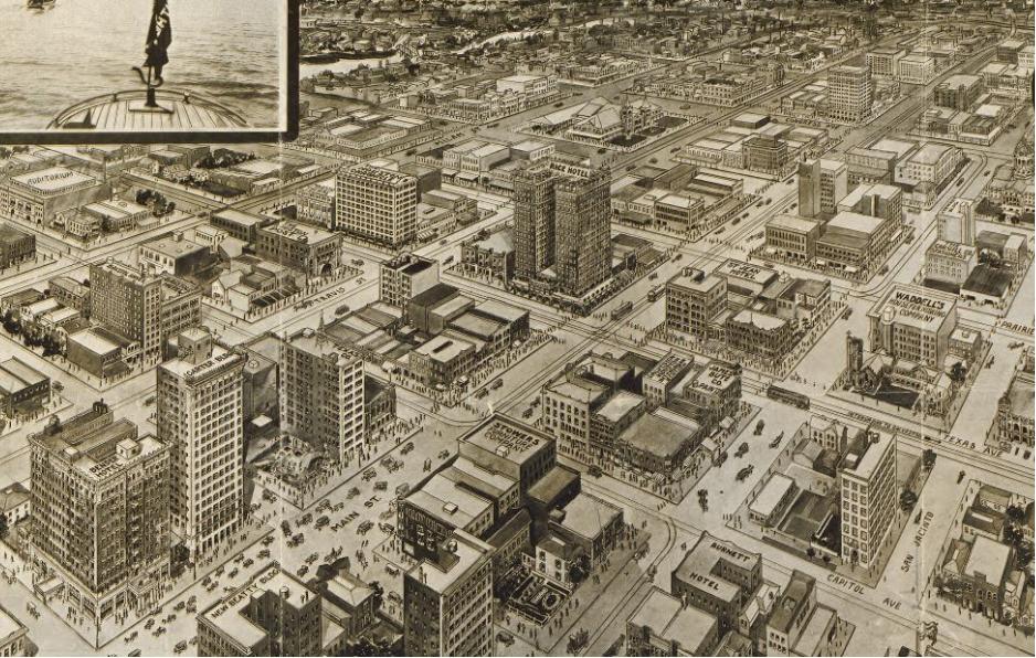
Anyone who has studied in an Architecture school, wherever it might
be, has already seen the picture on the left: a mindblowing angle of
downton Houston, the largest city in Texas. One instantly notices the
absurd amount of parking lots in one of the cities most valuable areas.
“Is this the kind of city we want?”, asks the teacher. Depending on the
automobile and losing pedestrian street life, one of the most debated
issues in urbanism today, is implicit to any observer.
The largest city in a state known to be the least regulated (Texas),
in the country which simbolizes freedom and deregulation to the rest of
the world. For the teacher and his students the case is closed: the
individualistic desire for the car and capitalist real-estate
speculation using lots as parking without the needed municipal
regulation is what generated this urban catastrophe. It is an undisputed
fact which deserves full attention of future urban planners so this
does not happen in our cities of the future.
It’s definitely a
motivating story, making young students enthusiastic to control their
cities in a sustainable way. Unfortunately, it is false.
I’ll give half a point to this story: one regulation Houston does not have is euclidian zoning,
the division between residential, commercial and industrial areas*. As
it is one of the most traditional ways of urban regulation, it created
the urban legend that no regulation existed at all. Nevertheless, today
it’s harder to find urbanists who support this kind of zoning, and on
both academic and blog circles much more is said about mixed used than
segregated uses.
I won’t give it a full point because in Houston there is covenant
zoning, neighborhood associations that agree among themselves what kind
of use it will have. But despite seeming voluntary and free, Houston is
one of the few north-american cities where City Hall itself will act
upon covenant residents who brake the rules, with the whole city paying
for the legal bills. This kind of regulation makes the city just
slightly less zoned, in practice, than american cities that maintain
euclidian zoning rules.
But let’s talk about what really matters, starting with urban
form. Legislation says that block should be at least 600ft wide, roughly
200m. Urbanists recommend pedestrian oriented planning to have blocks
around 300ft.
Long blocks make walkability hard as pedestrians don’t have exists to
adjacent streets, forcing them to walk along a hallway. Jane Jacobs also
commented on the importance of this feature on “Death and Life of Great
American Cities”:
“…frequent streets and short blocks are valuable because of the
fabric of intricate cross-use that they permit among the users of a city
neighbouhood.”
Another feature related to urban street form is the width, or the
size of the “right-of-way” in technical language. It’s pretty clear that
the wider the streets the worst things go for pedestrian and cyclists
as cars go faster and streets are harder and more dangerous to cross. In
Houston, major avenues must be at least 100ft wide (around 30m) and
regular streets around 50-60ft wide (around 20m). This is the scale of
the large avenues in São Paulo – hostile places for pedestrians, and
keep in mind Houston sidewalks are around only 4ft wide in average.
Houston was also one of the major targets of auto-oriented planning
as a way to curb transportation problems, greatly embraced by the public
sector in America, North and South, in the post-war period. In the 50’s
the US started the Interstate Highway System of America,
considered the largest public project in the history of mankind, with
75,440km of roads build and a $425 billion in taxpayer money.
Cities throughout the country developed away from city centers, today
commonly known as the suburbs,
towards the american dream of a townhouse in a green area with cars in
the garage. In Brasil we had the overpass decade, cutting up cities like
São Paulo and Porto Alegre and, of course, building Brasilia in 1957,
the city where sidewalks literally are nonexistent.
But this wasn’t enough for Houston. Even among large american cities
Houston is a top public spender in roads towards the suburbs, turning
the city less and less denser and more automobile-dependent. While most
american metropolis have one beltway around city centers, Houston has
two and may build a third. The city only has 10% more residents than
Boston with twice the number of freeways around it. Multibillion dollar
projects for more road building continue to make the City Hall busy
until today.
But things go even further. One of the regulations that influenced
Houston even more was minimum lot sizes, which until 1998 was 5000sqft
for a single-family townhouse (around 460sqm). In São Paulo, regular
lots are approximately 10m x15m (150sqm), with the possibility to build
multi-family or commercial buildings in this space. This anti-density
pro-sprawl legislation in Houston turns mass transit virtually
impossible as residents have to walk many blocks just to get to the bus
stop. And as a matter of fact, every single form of mass transit is
regulated by City Hall, from taxis to buses to rail.
 Now guess what is the cherry on top of Houston’s regulatory cake producing a downtown full of parking lots? The 1989 parking ordinance
– the good old failed attempt of the public sector trying to please its
citizens – mandating every new building to have loads of parkings
spaces. The numbers are much higher than San Francisco
which demands for 9 spaces for a high school with 18 classrooms against
171 spaces in Houston. SF demands 1 space per residence while Houston
1.25-2. In São Paulo, another great example of a traffic-oriented city
(with small lots but with a historically strong zoning code) demands 1 space for every 35-50sqm in non-residential projects, and an astonishing 3 spaces per residence when it surpasses 500sqm. Good news is that there are plans on removing this parking ordinance,
which unfortunately isn’t being talked about in São Paulo, Porto Alegre
or other brazilian capitals which maintain these rules created for the
comfort of drivers.
It’s also worth remembering that the city wasn’t always like this.
Since the beginning of the 20th century until before the automobile boom
incentivized by the public sector – in a much less regulated urban
environment – the city was closer to the New Urbanism ideal of today:
buildings of varying heights, mixed use and high density compared to
other cities at the time.
So the bottom line is that the image we see in urbanism classes is
just a small part of an extremely sprawled city, where most residents
have no other option of living if not isolated in the suburbs and
depending on the automobile for their daily routines. After this not so
brief legal and historical research it seems clear to me that the reason
for this is not lack of regulation, but a pretty obvious result of the
regulations enforced by the yes existing and enacting Houston Planning and Development Department.
* In practice this would naturally
occur with no regulation at all, as industries don’t have much
incentives to buy lots in expensive dense urban areas. Downtowns
themselves benefit from a spontaneous and natural existence of mixed
use, as this means constant urban life.
Additional recommended reading:
“How Overregulation Creates Sprawl (Even in a City without Zoning”, Michael Lewyn
“Is Houston Really Unplanned?”, Stephen Smith
Nota: as visões expressas no artigo não são necessariamente aquelas do Instituto Mises Brasil.